
Carte topographique Greater Hyderabad Municipal Corporation East Zone
Carte interactive
Cliquez sur la carte pour afficher l’altitude.
À propos de cette carte
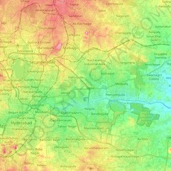
Nom : Carte topographique Greater Hyderabad Municipal Corporation East Zone, altitude, relief.
Altitude moyenne : 515 m
Altitude minimum : 447 m
Altitude maximum : 614 m
Autres cartes topographiques
Cliquez sur une carte pour visualiser sa topographie, son altitude et son relief.
Geological Survey of India
India > Telangana > Uppal mandal > Hyderabad
Geological Survey of India, Hyderabad, Uppal mandal, Medchal–Malkajgiri, Telangana, India
Altitude moyenne : 502 m