
Carte topographique Boones Mill
Carte interactive
Cliquez sur la carte pour afficher l’altitude.
À propos de cette carte
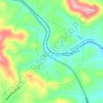
Nom : Carte topographique Boones Mill, altitude, relief.
Lieu : Boones Mill, Franklin County, Virginia, United States (37.10687 -79.95893 37.12478 -79.94342)
Altitude moyenne : 390 m
Altitude minimum : 326 m
Altitude maximum : 506 m
According to the United States Census Bureau, the town has a total area of 0.73 square miles (1.9 km2), all of it land. The town is in the valley of Maggodee Creek, a southeast-flowing tributary of the Blackwater River, part of the Roanoke River watershed. Murray Knob, elevation 2,286 feet (697 m), rises 2 miles (3 km) to the north on the crest of the Blue Ridge, and the eastern end of Cahas Mountain, at 2,992 feet (912 m), is 2 miles to the west.
Autres cartes topographiques
Cliquez sur une carte pour visualiser sa topographie, son altitude et son relief.
Smith Mountain Lake
United States > Virginia > Franklin County > North Shore
Smith Mountain Lake, Arrowhead, Franklin County, Virginia, United States
Altitude moyenne : 275 m
Mill Creek
United States > Virginia > Franklin County
Mill Creek, Franklin County, Virginia, 24102, United States
Altitude moyenne : 343 m
Henry Fork
United States > Virginia > Franklin County
Henry Fork, Franklin County, Virginia, 24151, United States
Altitude moyenne : 341 m
Henry
United States > Virginia > Franklin County
Henry, Franklin County, Virginia, 24102, United States
Altitude moyenne : 318 m
Callaway
United States > Virginia > Franklin County
Callaway, Franklin County, Virginia, 24067, United States
Altitude moyenne : 398 m
Redwood
United States > Virginia > Franklin County
Redwood, Franklin County, Virginia, 24092, United States
Altitude moyenne : 324 m
Bent Mountain
United States > Virginia > Franklin County
Bent Mountain, Franklin County, Virginia, 24059, United States
Altitude moyenne : 831 m
North Shore
United States > Virginia > Franklin County > Scruggs
North Shore, Scruggs, Franklin County, Virginia, United States
Altitude moyenne : 261 m
Lynville Mountain
United States > Virginia > Franklin County
Lynville Mountain, Franklin County, Virginia, 24101, United States
Altitude moyenne : 312 m
Wirtz
United States > Virginia > Franklin County
Wirtz, Franklin County, Virginia, United States
Altitude moyenne : 350 m
Union Hall
United States > Virginia > Franklin County
Union Hall, Franklin County, Virginia, 24176, United States
Altitude moyenne : 271 m
Rocky Mount
United States > Virginia > Franklin County
Rocky Mount, Franklin County, Virginia, United States
Altitude moyenne : 351 m
Ferrum
United States > Virginia > Franklin County
Ferrum, Franklin County, Virginia, United States
Altitude moyenne : 411 m
Penhook
United States > Virginia > Franklin County
Penhook, Franklin County, Virginia, 24137, United States
Altitude moyenne : 271 m