
Carte topographique Bagworth Heath Woods
Carte interactive
Cliquez sur la carte pour afficher l’altitude.
À propos de cette carte
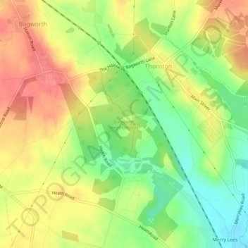
Nom : Carte topographique Bagworth Heath Woods, altitude, relief.
Altitude moyenne : 138 m
Altitude minimum : 102 m
Altitude maximum : 170 m
Autres cartes topographiques
Cliquez sur une carte pour visualiser sa topographie, son altitude et son relief.
Thornton Reservoir
United Kingdom > England > Leicestershire > Hinckley and Bosworth > Thornton
Thornton Reservoir, Bagworth & Thornton, Thornton, Hinckley and Bosworth, Leicestershire, England, United Kingdom
Altitude moyenne : 139 m