Géolocaliser

Carte topographique Cherupuzha

Cliquez sur la carte pour afficher l’altitude.

Cherupuzha

Surrounded by green terrains and mesmerizing hills, Tejaswini river in Cherupuzha offers adventurous tourist activity like white water rafting in Western ghats. Kollada near Cherupuzha is the starting point to kick off the rafting trip on the river. The rafting experience at Cherupuzha is an ideal stepping stone for those who aspires challenging high altitude rapids. Inflatable rafts are used here which is less expensive and easily maintained. White Water Rafting at Tejaswini river is one of the 17 best places for rafting in India.

Wikipedia (CC-BY-SA 3.0)

À propos de cette carte

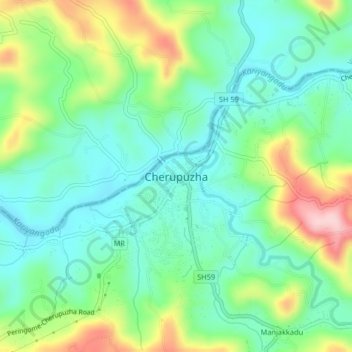
Nom : Carte topographique Cherupuzha, altitude, relief.

Lieu : Cherupuzha, Payyannur Taluk, Kannur District, Kerala, 670511, India (12.23265 75.32112 12.31265 75.40112)

Altitude moyenne : 124 m

Altitude minimum : 21 m

Altitude maximum : 408 m

Autres cartes topographiques

Cliquez sur une carte pour visualiser sa topographie, son altitude et son relief.

Payyannur

India > Kerala > Payyannur Taluk

Altitude moyenne : 47 m

Payyannur

India > Kerala > Payyannur Taluk > Kavvayi

Altitude moyenne : 19 m

Madayi

India > Kerala > Payyannur Taluk > Vengara

Altitude moyenne : 10 m

Ezhome

India > Kerala > Payyannur Taluk > Ezhom

Altitude moyenne : 14 m

Cherat

India > Kerala > Payyannur Taluk > Edat

Altitude moyenne : 7 m

Équipez-vous pour votre prochaine aventure :

🧣Écharpe thermique - Confort absolu pour les attentes statiques dans le froid
🧦Chaussettes de randonnée - Conception technique pour éviter les ampoules sur les longs dénivelés
🧥Veste polaire respirante - Couche intermédiaire idéale pour réguler la température corporelle
🌍Globes terrestres - Visualisation géographique
🧤Gants de montagne tactiles - Gardez vos mains au chaud tout en manipulant votre GPS ou smartphone

En tant que Partenaire Amazon, ce site perçoit une commission sur les achats éligibles sans surcoût pour vous.