
Carte topographique Savannah
Carte interactive
Cliquez sur la carte pour afficher l’altitude.
À propos de cette carte
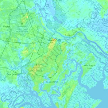
Nom : Carte topographique Savannah, altitude, relief.
Lieu : Savannah, Chatham County, Georgia, United States (31.88785 -81.37143 32.18966 -81.02952)
Altitude moyenne : 4 m
Altitude minimum : -5 m
Altitude maximum : 33 m
Savannah is prone to flooding, due to abundant rainfall, an elevation at just above sea level, and the shape of the coastline, which poses a greater surge risk during hurricanes. The city currently uses five canals. In addition, several pumping stations have been built to help reduce the effects of flash flooding.
Autres cartes topographiques
Cliquez sur une carte pour visualiser sa topographie, son altitude et son relief.
Oakdale
United States > Georgia > Chatham County > Savannah
Oakdale, Savannah, Chatham County, Georgia, 31406, United States
Altitude moyenne : 10 m
Thunderbolt
United States > Georgia > Chatham County
Thunderbolt, Chatham County, Georgia, United States
Altitude moyenne : 5 m
Welwood
United States > Georgia > Chatham County > Savannah
Welwood, Savannah, Chatham County, Georgia, 31409, United States
Altitude moyenne : 7 m
Tybee Island
United States > Georgia > Chatham County
Tybee Island, Chatham County, Georgia, 31328, United States
Altitude moyenne : 1 m
O'Leary
United States > Georgia > Chatham County > Port Wentworth > O'Leary
O'Leary, Port Wentworth, Chatham County, Georgia, 31407, United States
Altitude moyenne : 5 m