
Carte topographique Madison
Carte interactive
Cliquez sur la carte pour afficher l’altitude.
À propos de cette carte
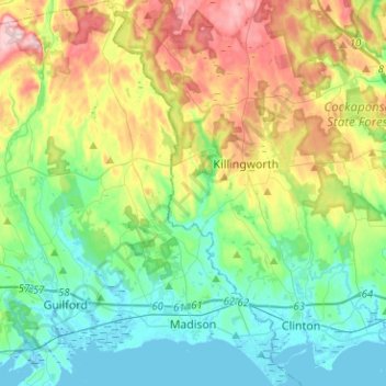
Nom : Carte topographique Madison, altitude, relief.
Altitude moyenne : 69 m
Altitude minimum : -2 m
Altitude maximum : 219 m
Autres cartes topographiques
Cliquez sur une carte pour visualiser sa topographie, son altitude et son relief.
Lake Whitney
United States > Connecticut > South Central COG > Hamden
Lake Whitney, Hamden, South Central COG, Connecticut, United States
Altitude moyenne : 25 m
Branford Hills
United States > Connecticut > South Central COG > Branford
Branford Hills, Branford, South Central COG, Connecticut, 06405, United States
Altitude moyenne : 12 m
North Guilford
United States > Connecticut > South Central COG > Guilford
North Guilford, Guilford, South Central COG, Connecticut, United States
Altitude moyenne : 79 m
Whitney Peak
United States > Connecticut > South Central COG > Hamden
Whitney Peak, Hamden, South Central COG, Connecticut, 06517, United States
Altitude moyenne : 19 m