
Carte topographique Lewiston
Carte interactive
Cliquez sur la carte pour afficher l’altitude.
À propos de cette carte
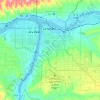
Nom : Carte topographique Lewiston, altitude, relief.
Lieu : Lewiston, Nez Perce County, Idaho, 83501, United States (46.36165 -117.04659 46.43711 -116.91126)
Altitude moyenne : 334 m
Altitude minimum : 219 m
Altitude maximum : 758 m
According to the U.S. Census Bureau, the city has a total area of 18.04 square miles (46.72 km2), of which 17.23 square miles (44.63 km2) is land and 0.81 square miles (2.10 km2) is water. Downtown Lewiston, at elevations between 740 feet (230 m) and 780 feet (240 m), is only slightly higher in elevation than the river, about 741 ft (226 m), which was thirty feet (9 m) lower prior to the completion of the Lower Granite Dam. Away from downtown the terrain gains elevation quickly, as the steep riverbank highway of U.S. 95 north of Lewiston ascends to 2,756 feet (840 m).
Autres cartes topographiques
Cliquez sur une carte pour visualiser sa topographie, son altitude et son relief.
Peck
United States > Idaho > Nez Perce County
Peck, Nez Perce County, Idaho, United States
Altitude moyenne : 492 m
Lenore
United States > Idaho > Nez Perce County
Lenore, Nez Perce County, Idaho, United States
Altitude moyenne : 401 m
Lapwai
United States > Idaho > Nez Perce County
Lapwai, Nez Perce County, Idaho, 83540, United States
Altitude moyenne : 364 m
Culdesac
United States > Idaho > Nez Perce County > Culdesac
Culdesac, Nez Perce County, Idaho, United States
Altitude moyenne : 588 m
Upper Cache Creek Rapids
United States > Idaho > Nez Perce County
Upper Cache Creek Rapids, Nez Perce County, Idaho, United States
Altitude moyenne : 484 m