
Carte topographique Latimer
Cliquez sur la carte pour afficher l’altitude.
À propos de cette carte
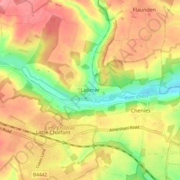
Nom : Carte topographique Latimer, altitude, relief.
Lieu : Latimer, Buckinghamshire, England, HP5 1TY, United Kingdom (51.65945 -0.56996 51.69945 -0.52996)
Altitude moyenne : 121 m
Altitude minimum : 70 m
Altitude maximum : 160 m
Autres cartes topographiques
Cliquez sur une carte pour visualiser sa topographie, son altitude et son relief.
Chilterns National Landscape
United Kingdom > England > Buckinghamshire
The highest point is at 267 m (876 ft.) above sea level at Haddington Hill near Wendover in Buckinghamshire; a stone monument marks the summit. The nearby Ivinghoe Beacon is a more prominent hill, although its altitude is only 249 m (817 ft.). It is the starting point of the Icknield Way Path and the Ridgeway…
Altitude moyenne : 102 m
Chiltern District
United Kingdom > England > Buckinghamshire > Buckland Common
Altitude moyenne : 137 m
Aylesbury
United Kingdom > England > Buckinghamshire
Aylesbury is immediately southeast of the upper River Thame that flows past Thame to Dorchester on Thames and is partly sited on the two northernmost outcrops of Portland (lime)stone in England bisected by a small stream, Bear Brook which gives a relatively prominent position in relation to the terrain of all…
Altitude moyenne : 85 m
Beaconsfield and Chepping Wye Community Board
United Kingdom > England > Buckinghamshire > Knotty Green
Altitude moyenne : 115 m