
Carte topographique Somerset
Carte interactive
Cliquez sur la carte pour afficher l’altitude.
À propos de cette carte
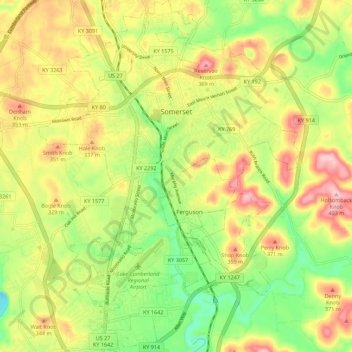
Nom : Carte topographique Somerset, altitude, relief.
Lieu : Somerset, Pulaski County, Kentucky, 42503, United States (37.03135 -84.64756 37.12006 -84.56484)
Altitude moyenne : 295 m
Altitude minimum : 202 m
Altitude maximum : 398 m
Somerset is located at 37°4′59″N 84°36′34″W / 37.08306°N 84.60944°W / 37.08306; -84.60944 (37.082966, −84.609387),[7] and the downtown (central) part of the city is at an elevation of 974 feet above sea level. The city is located at the eastern end of Kentucky's Mississippian Plateau (or Pennyroyal Plateau); however, the micropolitan area extends eastward into the Appalachian Plateau (or Eastern Kentucky Coalfield), and northward to Kentucky's Outer Bluegrass region. Thus, the area shows significant variations in landforms and scenery.
Autres cartes topographiques
Cliquez sur une carte pour visualiser sa topographie, son altitude et son relief.
Bronston
United States > Kentucky > Pulaski County
Bronston, Pulaski County, Kentucky, 42518, United States
Altitude moyenne : 248 m
Drum
United States > Kentucky > Pulaski County
Drum, Pulaski County, Kentucky, United States
Altitude moyenne : 332 m