
Carte topographique Redland
Carte interactive
Cliquez sur la carte pour afficher l’altitude.
À propos de cette carte
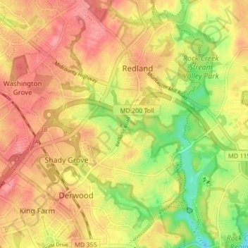
Nom : Carte topographique Redland, altitude, relief.
Lieu : Redland, Montgomery County, Maryland, 20855, United States (39.10600 -77.17585 39.15933 -77.11507)
Altitude moyenne : 137 m
Altitude minimum : 87 m
Altitude maximum : 169 m
Autres cartes topographiques
Cliquez sur une carte pour visualiser sa topographie, son altitude et son relief.
Flower Hill
United States > Maryland > Montgomery County > Redland
Flower Hill, Redland, Montgomery County, Maryland, 20879, United States
Altitude moyenne : 147 m
Lake Needwood
United States > Maryland > Montgomery County > Redland > Avery
Lake Needwood, Avery, Redland, Montgomery County, Maryland, United States
Altitude moyenne : 122 m