
Carte topographique Bazargan
Carte interactive
Cliquez sur la carte pour afficher l’altitude.
À propos de cette carte
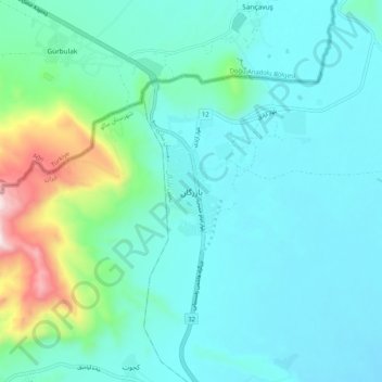
Nom : Carte topographique Bazargan, altitude, relief.
Altitude moyenne : 1’507 m
Altitude minimum : 1’366 m
Altitude maximum : 2’189 m
Until well within the 20th century, Bazargan was not much more than a small village, located at an altitude of 1,550 meters on a delta above the Aqchay river. Bazargan's inhabitants, of Turkic origin, were generally involved in traditional agricultural activities. In 1913, the village was ceded by the Ottoman Empire to Qajar Iran. The village of Bazargan has only developed recently (and that in a limited way), due to the existence of the nearby frontier crossing with Turkey.[4]
Autres cartes topographiques
Cliquez sur une carte pour visualiser sa topographie, son altitude et son relief.
Malham
Iran > West Azerbaijan Province > Maku County
Malham, بخش بازرگان, Maku County, West Azerbaijan Province, Iran
Altitude moyenne : 1’277 m