Carte topographique Wittersham
Carte interactive
Cliquez sur la carte pour afficher l’altitude.
À propos de cette carte
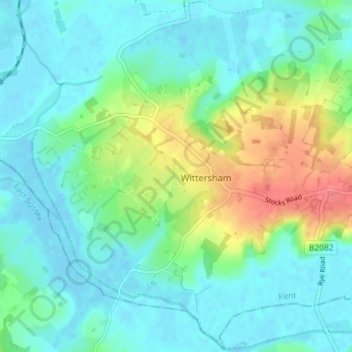
Autres cartes topographiques
Cliquez sur une carte pour visualiser sa topographie, son altitude et son relief.
Smeeth
United Kingdom > England > Kent > Ashford
Smeeth, Ashford, Kent, South East England, England, United Kingdom
Altitude moyenne : 67 m
Shirkoak
United Kingdom > England > Kent > Ashford > Woodchurch > Shirkoak
Shirkoak, Woodchurch, Ashford, Kent, South East England, England, TN26 3QP, United Kingdom
Altitude moyenne : 38 m
Repton
United Kingdom > England > Kent > Ashford
Repton, Repton Park, Orchard Heights, Ashford, Kent, South East England, England, United Kingdom
Altitude moyenne : 55 m