
Carte topographique Ischigualasto Provincial Park
Carte interactive
Cliquez sur la carte pour afficher l’altitude.
À propos de cette carte
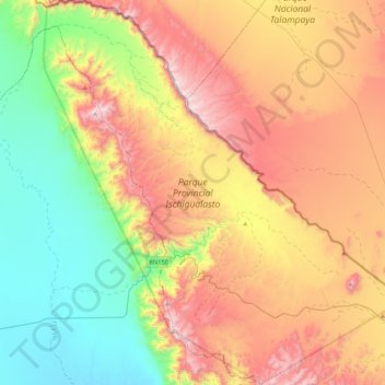
Nom : Carte topographique Ischigualasto Provincial Park, altitude, relief.
Altitude moyenne : 1’258 m
Altitude minimum : 758 m
Altitude maximum : 1’929 m
Most of the park lies within the Valle Fértil Department, with a minor part in the Jachal Department of San Juan, at an altitude of about 1,300 m (4,300 ft) amsl. The park is part of the western border of the Central Sierras, and it features typical desert vegetation (bushes, cacti and some trees) which covers between 10 and 20% of the area. The climate is very dry, with rainfall mostly during the summer, and temperature extremes (minimum −10 °C or 14 °F, maximum 45 °C or 113 °F). There is a constant southern wind with a speed of 20–40 km/h (12–25 mph) after noon and until the evening, sometimes accompanied by the extremely strong Zonda wind.
Autres cartes topographiques
Cliquez sur une carte pour visualiser sa topographie, son altitude et son relief.
Villa San Andrés
Villa San Andrés, Capital, San Juan, Argentina
Altitude moyenne : 661 m
Quebrada Seca
Quebrada Seca, Iglesia, San Juan, Argentina
Altitude moyenne : 4’334 m
Hediondo (o Rincón del Diablo)
Hediondo (o Rincón del Diablo), Iglesia, San Juan, Argentina
Altitude moyenne : 4’025 m
Parkinson Hill
Parkinson Hill, Zonda, San Juan, 5478, Argentina
Altitude moyenne : 1’336 m
Quebrada Seca
Quebrada Seca, Calingasta, San Juan, Argentina
Altitude moyenne : 3’106 m
Cerro Mercedario
Cerro Mercedario, Calingasta, San Juan, Argentina
Altitude moyenne : 6’128 m