
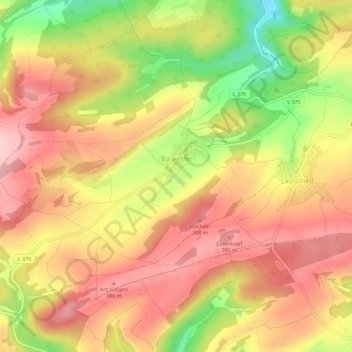
Carte topographique Bärweiler
Carte interactive
Cliquez sur la carte pour afficher l’altitude.
À propos de cette carte
Nom : Carte topographique Bärweiler, altitude, relief.
Altitude moyenne : 327 m
Altitude minimum : 208 m
Altitude maximum : 404 m
Bärweiler lies in picturesque hilly land between Bad Sobernheim and Meisenheim. The residential community characterized by agriculture has a municipal area measuring 611 ha. The municipality lies 10 km from Bad Sobernheim, 13 km from Kirn, 10 km from Meisenheim and roughly 30 km from the district seat, Bad Kreuznach. The village, which lies south of the Nahe, belongs to the northernmost part of the Saar-Nahe Uplands and Hills, more precisely to the Sien-Lauschied Ridge in the Meisenheim Uplands (Glan-Alsenz Mountains). Because of the lively breaking-up of the landscape into scattered, wooded hillocks and ridges, hollows and open plateau remnants, the countryside is also described as “humpy land”. The highest elevation in the municipality reaches 393.0 m above sea level, while the lowest point is 225.3 m above sea level.
Autres cartes topographiques
Cliquez sur une carte pour visualiser sa topographie, son altitude et son relief.
Langenthal
Germany > Rhineland-Palatinate > Landkreis Bad Kreuznach
Langenthal, Nahe-Glan, Landkreis Bad Kreuznach, Rhineland-Palatinate, Germany
Altitude moyenne : 319 m
Rüdesheim
Germany > Rhineland-Palatinate > Landkreis Bad Kreuznach
Rüdesheim, Landkreis Bad Kreuznach, Rhineland-Palatinate, 55593, Germany
Altitude moyenne : 165 m
Rheingrafenstein
Germany > Rhineland-Palatinate > Landkreis Bad Kreuznach > Bad Kreuznach
Rheingrafenstein, Bad Kreuznach, Landkreis Bad Kreuznach, Rhineland-Palatinate, 55583, Germany
Altitude moyenne : 218 m