
Carte topographique Sohra (Cherrapunji)
Carte interactive
Cliquez sur la carte pour afficher l’altitude.
À propos de cette carte
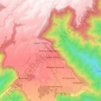
Nom : Carte topographique Sohra (Cherrapunji), altitude, relief.
Altitude moyenne : 1’169 m
Altitude minimum : 261 m
Altitude maximum : 1’652 m
It has an average elevation of 1,430 metres (4,690 ft) and sits on a plateau in the southern part of the Khasi Hills, facing the plains of Bangladesh. The plateau rises 660 meters above the surrounding valleys.
Autres cartes topographiques
Cliquez sur une carte pour visualiser sa topographie, son altitude et son relief.
Sohsarat
India > Meghalaya > Shella Bholaganj > Nongwar
Sohsarat, Nongwar, Shella Bholaganj, East Khasi Hills District, Meghalaya, India
Altitude moyenne : 372 m
Nongthymmai
India > Meghalaya > Shella Bholaganj
Nongthymmai, Shella Bholaganj, East Khasi Hills District, Meghalaya, 793108, India
Altitude moyenne : 1’123 m
Suktia
India > Meghalaya > Shella Bholaganj
Suktia, Shella Bholaganj, East Khasi Hills, Meghalaya, India
Altitude moyenne : 486 m
Nohsngithiang Falls (Seven Sisters)
India > Meghalaya > Shella Bholaganj
Nohsngithiang Falls (Seven Sisters), Shella Bholaganj, East Khasi Hills, Meghalaya, 793108, India
Altitude moyenne : 1’043 m
Nohkalikai Falls View Point
India > Meghalaya > Shella Bholaganj
Nohkalikai Falls View Point, Root bridge, Shella Bholaganj, East Khasi Hills, Meghalaya, 793108, India
Altitude moyenne : 1’156 m