
Faire un don
Équipez-vous pour votre prochaine aventure :
En tant que Partenaire Amazon, ce site perçoit une commission sur les achats éligibles sans surcoût pour vous.
Carte topographique Dewey-Humboldt
Cliquez sur la carte pour afficher l’altitude.
Faire un don
Équipez-vous pour votre prochaine aventure :
En tant que Partenaire Amazon, ce site perçoit une commission sur les achats éligibles sans surcoût pour vous.
À propos de cette carte
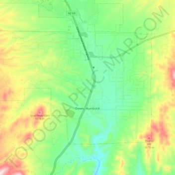
Nom : Carte topographique Dewey-Humboldt, altitude, relief.
Altitude moyenne : 1’464 m
Altitude minimum : 1’302 m
Altitude maximum : 1’737 m
Faire un don
Équipez-vous pour votre prochaine aventure :
En tant que Partenaire Amazon, ce site perçoit une commission sur les achats éligibles sans surcoût pour vous.
Autres cartes topographiques
Cliquez sur une carte pour visualiser sa topographie, son altitude et son relief.
Black Canyon City
United States > Arizona > Yavapai County
Black Canyon City is located at 34°4′11″N 112°8′22″W / 34.06972°N 112.13944°W / 34.06972; -112.13944 (34.069719, -112.139466), at an elevation of 1,975 feet (602 m).
Altitude moyenne : 700 m
Faire un don
Équipez-vous pour votre prochaine aventure :
En tant que Partenaire Amazon, ce site perçoit une commission sur les achats éligibles sans surcoût pour vous.
Seligman
United States > Arizona > Yavapai County > Seligman
Seligman is located at 35°19′42″N 112°52′27″W / 35.32833°N 112.87417°W / 35.32833; -112.87417 (35.328199, −112.874303), at 5,240 feet (1,600 m) in elevation, alongside the Big Chino Wash, in a northern section of Chino Valley. The wash is a major tributary of the Verde River. Seligman is…
Altitude moyenne : 1’617 m
Faire un don
Équipez-vous pour votre prochaine aventure :
En tant que Partenaire Amazon, ce site perçoit une commission sur les achats éligibles sans surcoût pour vous.
Faire un don
Équipez-vous pour votre prochaine aventure :
En tant que Partenaire Amazon, ce site perçoit une commission sur les achats éligibles sans surcoût pour vous.
Cedar Bench Wilderness
United States > Arizona > Yavapai County
Cedar Bench Wilderness is a protected wilderness area in the Prescott National Forest in the U.S. state of Arizona. Established in 1984 under the Arizona Wilderness Act, the area protects the large "bench" that divides the Agua Fria and Verde River drainages. Elevations range from 4,500 feet (1,371 m) to 6,700…
Altitude moyenne : 1’349 m
Faire un don
Équipez-vous pour votre prochaine aventure :
En tant que Partenaire Amazon, ce site perçoit une commission sur les achats éligibles sans surcoût pour vous.
Arcosanti
United States > Arizona > Yavapai County
Arcosanti is a projected experimental town with a bronze bell casting business in Yavapai County, central Arizona, United States, 70 mi (110 km) north of Phoenix, at an elevation of 3,732 feet (1,138 m). Its arcology concept was proposed by Italian-American architect Paolo Soleri (1919–2013). He began…
Altitude moyenne : 1’130 m
Faire un don
Équipez-vous pour votre prochaine aventure :
En tant que Partenaire Amazon, ce site perçoit une commission sur les achats éligibles sans surcoût pour vous.
Faire un don
Équipez-vous pour votre prochaine aventure :
En tant que Partenaire Amazon, ce site perçoit une commission sur les achats éligibles sans surcoût pour vous.