Géolocaliser
👉 Easily get elevation data in JSON, GeoTIFF and KML formats using Elevation API
Merci de soutenir ce site ❤️
Faire un don

Équipez-vous pour votre prochaine aventure :

En tant que Partenaire Amazon, ce site perçoit une commission sur les achats éligibles sans surcoût pour vous.

Carte topographique Elberton

Cliquez sur la carte pour afficher l’altitude.

À propos de cette carte

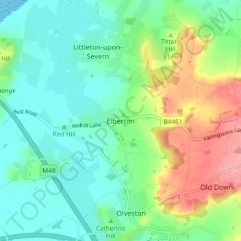
Nom : Carte topographique Elberton, altitude, relief.

Lieu : Elberton, Aust, South Gloucestershire, West of England, England, BS35 4AF, United Kingdom (51.57514 -2.59898 51.61514 -2.55898)

Altitude moyenne : 30 m

Altitude minimum : 0 m

Altitude maximum : 93 m

Autres cartes topographiques

Cliquez sur une carte pour visualiser sa topographie, son altitude et son relief.

Pucklechurch

United Kingdom > England > South Gloucestershire

Shortwood is located to the east of the A4174 and to the west of Pucklechurch village, sitting lower in the landscape topography against the Pucklechurch ridge and adjacent to Emerson’s Green and Mangotsfield. It is largely a linear settlement (comprising approximately 73 households) washed over by the Green…

Altitude moyenne : 98 m

Aust

United Kingdom > England > South Gloucestershire

Altitude moyenne : 9 m

Sodbury

United Kingdom > England > South Gloucestershire

Altitude moyenne : 122 m

Horton

United Kingdom > England > South Gloucestershire

Altitude moyenne : 132 m

Badminton

United Kingdom > England > South Gloucestershire

Altitude moyenne : 133 m

Filton

United Kingdom > England > South Gloucestershire

Altitude moyenne : 67 m

Bitton

United Kingdom > England > South Gloucestershire

Altitude moyenne : 83 m

Siston

United Kingdom > England > South Gloucestershire

Altitude moyenne : 80 m

Tormarton

United Kingdom > England > South Gloucestershire

Altitude moyenne : 159 m

Wickwar

United Kingdom > England > South Gloucestershire

Altitude moyenne : 72 m

Yate

United Kingdom > England > South Gloucestershire

Altitude moyenne : 83 m

Pucklechurch

United Kingdom > England > South Gloucestershire

The land of Pucklechurch is relatively prominent in elevation compared to surrounding areas and as such it was selected in the Bronze Age as the site of a tumulus (round barrow) at Shortwood Hill.

Altitude moyenne : 98 m

Dodington

United Kingdom > England > South Gloucestershire

Altitude moyenne : 141 m

Doynton

United Kingdom > England > South Gloucestershire

Altitude moyenne : 129 m

Équipez-vous pour votre prochaine aventure :

🎒Sac d'hydratation VTT - Design ergonomique pour ne pas gêner les mouvements en descente
🦯Bâtons de marche - Réduisez la fatigue musculaire lors des fortes pentes et descentes
🧤Chaufferettes - Un confort indispensable pour les journées de grand froid
📷Appareils photo outdoor - Capture en conditions difficiles
🪜Bâtons de marche - Bâtons télescopiques pour stabilité et endurance

En tant que Partenaire Amazon, ce site perçoit une commission sur les achats éligibles sans surcoût pour vous.