
Carte topographique Tieton
Carte interactive
Cliquez sur la carte pour afficher l’altitude.
À propos de cette carte
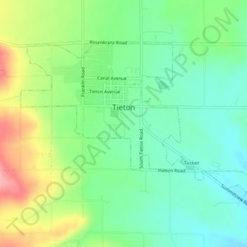
Nom : Carte topographique Tieton, altitude, relief.
Lieu : Tieton, Yakima County, Washington, 98947, United States (46.69081 -120.77257 46.70955 -120.73126)
Altitude moyenne : 594 m
Altitude minimum : 553 m
Altitude maximum : 669 m
Autres cartes topographiques
Cliquez sur une carte pour visualiser sa topographie, son altitude et son relief.
Naches Heights
United States > Washington > Yakima County
Naches Heights, Yakima County, Washington, United States
Altitude moyenne : 501 m
Ahtanum State Forest
United States > Washington > Yakima County
Ahtanum State Forest, Yakima County, Washington, United States
Altitude moyenne : 1’214 m
Zillah
United States > Washington > Yakima County
Zillah, Yakima County, Washington, 98953, United States
Altitude moyenne : 260 m
Selah
United States > Washington > Yakima County > Selah
Selah, Yakima County, Washington, 98942, United States
Altitude moyenne : 395 m