
Carte topographique Keyworth
Cliquez sur la carte pour afficher l’altitude.
À propos de cette carte
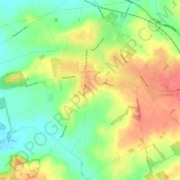
Nom : Carte topographique Keyworth, altitude, relief.
Altitude moyenne : 68 m
Altitude minimum : 39 m
Altitude maximum : 99 m
Autres cartes topographiques
Cliquez sur une carte pour visualiser sa topographie, son altitude et son relief.
Stanton on the Wolds
United Kingdom > England > Nottinghamshire > Rushcliffe > Stanton on the Wolds
Altitude moyenne : 78 m
Bassingfield
United Kingdom > England > Nottinghamshire > Rushcliffe > Holme Pierrepont > Bassingfield
Altitude moyenne : 28 m
Archers Lake
United Kingdom > England > Nottinghamshire > Rushcliffe > Bingham
Altitude moyenne : 28 m