
Carte topographique Leighton Buzzard
Cliquez sur la carte pour afficher l’altitude.
À propos de cette carte
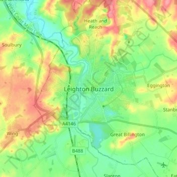
Nom : Carte topographique Leighton Buzzard, altitude, relief.
Altitude moyenne : 103 m
Altitude minimum : 72 m
Altitude maximum : 151 m
Autres cartes topographiques
Cliquez sur une carte pour visualiser sa topographie, son altitude et son relief.
Northill
United Kingdom > England > Central Bedfordshire
Topographically, Northill stands on a slightly elevated ridge that runs north to south. The village lies on the border of the Bedfordshire and Cambridgeshire Claylands and the Bedfordshire Greensand Ridge; National Character Areas designated by Natural England. Central Bedfordshire Council has classified the…
Altitude moyenne : 37 m
Dunstable Downs
United Kingdom > England > Central Bedfordshire > Church End
Because of its elevation, Dunstable Downs hosted a station in the shutter telegraph chain which connected the Admiralty in London to its naval ships in the port of Great Yarmouth during the years 1808 to 1814.
Altitude moyenne : 178 m
Edgecote
United Kingdom > England > Central Bedfordshire > Caddington > Aley Green
Altitude moyenne : 168 m
Houghton Hall Park
United Kingdom > England > Central Bedfordshire > Houghton Regis
Altitude moyenne : 134 m
Dog Kennel Down
United Kingdom > England > Central Bedfordshire > Houghton Regis
Altitude moyenne : 138 m
Leighton-Linslade
United Kingdom > England > Central Bedfordshire > Leighton Buzzard
Altitude moyenne : 100 m
Wrestlingworth and Cockayne Hatley
United Kingdom > England > Central Bedfordshire
Altitude moyenne : 51 m
Husborne Crawley
United Kingdom > England > Central Bedfordshire > Husborne Crawley
Altitude moyenne : 97 m
Totternhoe Knolls
United Kingdom > England > Central Bedfordshire > Church End > Lower End
Altitude moyenne : 105 m
Gravenhurst
United Kingdom > England > Central Bedfordshire > Upper Gravenhurst
Altitude moyenne : 59 m
Crawley Park
United Kingdom > England > Central Bedfordshire > Aspley Guise > Husborne Crawley
Altitude moyenne : 98 m
Gravenhurst
United Kingdom > England > Central Bedfordshire > Upper Gravenhurst
Altitude moyenne : 59 m