Géolocaliser

Carte topographique Cubbington

Cliquez sur la carte pour afficher l’altitude.

À propos de cette carte

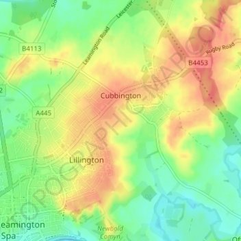
Nom : Carte topographique Cubbington, altitude, relief.

Lieu : Cubbington, Warwick, Warwickshire, England, United Kingdom (52.28955 -1.52830 52.32754 -1.47256)

Altitude moyenne : 77 m

Altitude minimum : 51 m

Altitude maximum : 104 m

Autres cartes topographiques

Cliquez sur une carte pour visualiser sa topographie, son altitude et son relief.

Catchem's End

United Kingdom > England > Warwickshire > Warwick > Hatton

Altitude moyenne : 98 m

Leek Wootton

United Kingdom > England > Warwickshire > Warwick

Altitude moyenne : 76 m

Chessetts Wood

United Kingdom > England > Warwickshire > Warwick > Lapworth

Altitude moyenne : 115 m

Haseley Knob

United Kingdom > England > Warwickshire > Warwick > Wroxall

Altitude moyenne : 117 m

Équipez-vous pour votre prochaine aventure :

🌍Globes terrestres - Visualisation géographique
🍯Barres énergétiques - Coup de boost rapide lors des ascensions difficiles
📚Guides de trekking - Préparer ses expéditions
🧴Crèmes solaires haute protection - Protection UV renforcée
🧷Kit de réparation textile - Réparez un accroc sur votre veste ou votre tente immédiatement

En tant que Partenaire Amazon, ce site perçoit une commission sur les achats éligibles sans surcoût pour vous.