
Carte topographique Newtown
Cliquez sur la carte pour afficher l’altitude.
À propos de cette carte
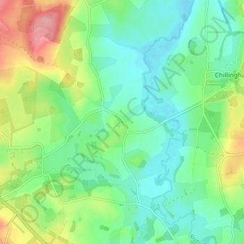
Nom : Carte topographique Newtown, altitude, relief.
Altitude moyenne : 82 m
Altitude minimum : 46 m
Altitude maximum : 158 m
Autres cartes topographiques
Cliquez sur une carte pour visualiser sa topographie, son altitude et son relief.
Berwick-upon-Tweed
United Kingdom > England > Northumberland
In the 1840s, Samuel Lewis included similar entries for Berwick-upon-Tweed in both his England and Scotland Topographical Dictionary. Berwick remained a county in its own right, and remained a separate parliamentary constituency until 1885 when it was merged to become a division of Northumberland under the…
Altitude moyenne : 33 m
Holy Island of Lindisfarne
United Kingdom > England > Northumberland > Holy Island
Altitude moyenne : 1 m
North Hazelrigg
United Kingdom > England > Northumberland > Chatton > North Hazelrigg
Altitude moyenne : 99 m
Catcleugh Reservoir
United Kingdom > England > Northumberland
Catcleugh Reservoir is a reservoir in Northumberland, England, adjacent to the A68 road just north of Byrness and to the southeast of the border with Scotland. It has a surface area of 98.654 ha and a mean depth of 9.8 m, a catchment area of 4007.5 ha, and is situated at 247 m altitude.
Altitude moyenne : 316 m