
Carte topographique Chalford Hill
Carte interactive
Cliquez sur la carte pour afficher l’altitude.
À propos de cette carte
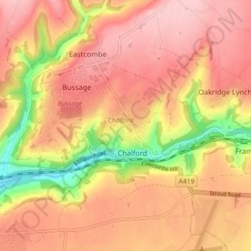
Nom : Carte topographique Chalford Hill, altitude, relief.
Altitude moyenne : 175 m
Altitude minimum : 61 m
Altitude maximum : 239 m
Autres cartes topographiques
Cliquez sur une carte pour visualiser sa topographie, son altitude et son relief.
France Lynch
United Kingdom > England > Gloucestershire > Stroud > Chalford
France Lynch, Chalford, Stroud, Gloucestershire, England, GL6 8LU, United Kingdom
Altitude moyenne : 180 m