
Carte topographique Friedrichsfelde
Carte interactive
Cliquez sur la carte pour afficher l’altitude.
À propos de cette carte
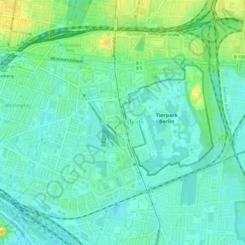
Nom : Carte topographique Friedrichsfelde, altitude, relief.
Lieu : Friedrichsfelde, Lichtenberg, Berlin, Germany (52.49096 13.49279 52.51462 13.54173)
Altitude moyenne : 43 m
Altitude minimum : 34 m
Altitude maximum : 59 m
Autres cartes topographiques
Cliquez sur une carte pour visualiser sa topographie, son altitude et son relief.
Battle of Berlin
Battle of Berlin, Gertrud-Kolmar-Straße, Dorotheenstadt, Mitte, Berlin, 10117, Germany
Altitude moyenne : 39 m
Friedrichshain-Kreuzberg
Friedrichshain-Kreuzberg, Berlin, Germany
Altitude moyenne : 45 m
Charlottenburg-Wilmersdorf
Charlottenburg-Wilmersdorf, Berlin, Germany
Altitude moyenne : 44 m