
Carte topographique Bee Cave
Cliquez sur la carte pour afficher l’altitude.
Bee Cave
According to the United States Census Bureau in 2010, the city has a total area of 2.6 square miles (6.7 km2), all of it land. Prior to the 2010 census, Bee Cave went from being a village to being a city, increasing its area to 6.8 square miles (18 km2), all land. It borders Lakeway to the northwest. The landscape of Bee Cave is generally hilly, with elevations ranging from 875 to 1025 feet (265–310 m).
À propos de cette carte
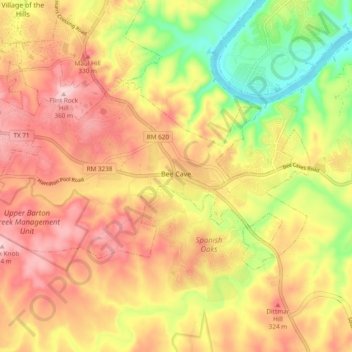
Nom : Carte topographique Bee Cave, altitude, relief.
Lieu : Bee Cave, Travis County, Texas, United States (30.28614 -98.00369 30.32981 -97.90868)
Altitude moyenne : 270 m
Altitude minimum : 148 m
Altitude maximum : 363 m
Autres cartes topographiques
Cliquez sur une carte pour visualiser sa topographie, son altitude et son relief.
Roy G. Guerrero Colorado River Metro Park
United States > Texas > Travis County > Austin
Altitude moyenne : 141 m
Austin
United States > Texas > Travis County > Austin
The elevation of Austin varies from 425 feet (130 m) to approximately 1,000 feet (305 m) above sea level. Due to the fact it straddles the Balcones Fault, much of the eastern part of the city is flat, with heavy clay and loam soils, whereas the western part and western suburbs consist of rolling hills on the…
Altitude moyenne : 203 m
Pflugerville
United States > Texas > Travis County > Pflugerville > Pflugerville
Altitude moyenne : 219 m