
Carte topographique Rietberg
Carte interactive
Cliquez sur la carte pour afficher l’altitude.
À propos de cette carte
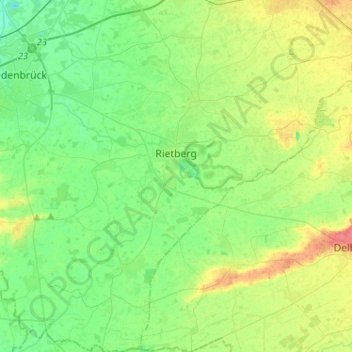
Nom : Carte topographique Rietberg, altitude, relief.
Altitude moyenne : 82 m
Altitude minimum : 65 m
Altitude maximum : 115 m
Autres cartes topographiques
Cliquez sur une carte pour visualiser sa topographie, son altitude et son relief.
Verl
Germany > North Rhine-Westphalia > Kreis Gütersloh > Verl
Verl, Kreis Gütersloh, North Rhine-Westphalia, 33415, Germany
Altitude moyenne : 93 m