
Carte topographique Veyo
Carte interactive
Cliquez sur la carte pour afficher l’altitude.
À propos de cette carte
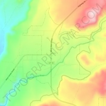
Nom : Carte topographique Veyo, altitude, relief.
Lieu : Veyo, Washington County, Utah, 84782, United States (37.31862 -113.71229 37.35862 -113.67229)
Altitude moyenne : 1’379 m
Altitude minimum : 1’228 m
Altitude maximum : 1’545 m
The town lies along State Route 18 north of the city of St. George, the county seat of Washington County. The elevation of Veyo is 4,485 feet (1,367 m). Although Veyo is unincorporated, it has a post office with the ZIP code of 84782. The population was 483 at the 2010 census. One tradition says the community name is an acronym of virtue, enterprise, youth, and order; another says it combines verdure and youth. There is a town of Veyo in Spain that is also referred to as La Peña, which means "rocky outcrop".
Autres cartes topographiques
Cliquez sur une carte pour visualiser sa topographie, son altitude et son relief.
St. George
United States > Utah > Washington County
St. George, Washington County, Utah, United States
Altitude moyenne : 929 m
Zion National Park
United States > Utah > Washington County
Zion National Park, Washington County, Utah, United States
Altitude moyenne : 1’877 m
Pine Valley
United States > Utah > Washington County
Pine Valley, Washington County, Utah, 84781, United States
Altitude moyenne : 2’092 m
Dammeron Valley
United States > Utah > Washington County
Dammeron Valley, Washington County, Utah, 84783, United States
Altitude moyenne : 1’444 m
Sand Mountain
United States > Utah > Washington County
Sand Mountain, Washington County, Utah, United States
Altitude moyenne : 1’190 m
Toquerville
United States > Utah > Washington County
Toquerville, Washington County, Utah, 84774, United States
Altitude moyenne : 1’301 m
Gunlock
United States > Utah > Washington County
Gunlock, Washington County, Utah, 84733, United States
Altitude moyenne : 1’210 m
Hildale
United States > Utah > Washington County
Hildale, Washington County, Utah, 84784, United States
Altitude moyenne : 1’763 m
Snow Canyon State Park
United States > Utah > Washington County
Snow Canyon State Park, Washington County, Utah, 84738, United States
Altitude moyenne : 1’169 m
Pintura
United States > Utah > Washington County
Pintura, Washington County, Utah, United States
Altitude moyenne : 1’382 m
Silver Reef
United States > Utah > Washington County > Leeds
Silver Reef, Leeds, Washington County, Utah, 84746, United States
Altitude moyenne : 1’185 m
Bee Hive
United States > Utah > Washington County
Bee Hive, Washington County, Utah, 84767, United States
Altitude moyenne : 1’651 m
Kolob Reservoir
United States > Utah > Washington County
Kolob Reservoir, Washington County, Utah, United States
Altitude moyenne : 2’499 m
Virgin
United States > Utah > Washington County > Virgin
Virgin, Washington County, Utah, United States
Altitude moyenne : 1’251 m
Washington
United States > Utah > Washington County
Washington, Washington County, Utah, 84780, United States
Altitude moyenne : 924 m
Mount Baldy
United States > Utah > Washington County
Mount Baldy, Washington County, Utah, United States
Altitude moyenne : 2’352 m
Zion Lodge
United States > Utah > Washington County
Zion Lodge, Washington County, Utah, United States
Altitude moyenne : 1’722 m
Hurricane Hill
United States > Utah > Washington County > Hurricane
Hurricane Hill, Hurricane, Washington County, Utah, 84745, United States
Altitude moyenne : 1’074 m
New Harmony
United States > Utah > Washington County > New Harmony
New Harmony, Washington County, Utah, United States
Altitude moyenne : 1’636 m
Hurricane
United States > Utah > Washington County
Hurricane, Washington County, Utah, United States
Altitude moyenne : 1’154 m
Pine Valley
United States > Utah > Washington County > Pine Valley
Pine Valley, Washington County, Utah, 84781, United States
Altitude moyenne : 2’075 m
Springdale
United States > Utah > Washington County
Springdale, Washington County, Utah, 84767, United States
Altitude moyenne : 1’349 m
Bloomington Hill
United States > Utah > Washington County > St. George
Bloomington Hill, St. George, Washington County, Utah, 84770-1858, United States
Altitude moyenne : 810 m
Hurricane
United States > Utah > Washington County > Hurricane > Hurricane
Hurricane, Washington County, Utah, 84745, United States
Altitude moyenne : 1’075 m
Central
United States > Utah > Washington County > Central
Central, Washington County, Utah, 84722, United States
Altitude moyenne : 1’636 m
Watchman Trailhead
United States > Utah > Washington County > Springdale
Watchman Trailhead, Springdale, Washington County, Utah, 84767, United States
Altitude moyenne : 1’316 m
Enterprise
United States > Utah > Washington County
Enterprise, Washington County, Utah, 84725, United States
Altitude moyenne : 1’690 m
Ivins
United States > Utah > Washington County
Ivins, Washington County, Utah, 84738, United States
Altitude moyenne : 1’007 m
La Verkin
United States > Utah > Washington County
La Verkin, Washington County, Utah, United States
Altitude moyenne : 1’117 m