
Carte topographique Chihuahuan Desert
Carte interactive
Cliquez sur la carte pour afficher l’altitude.
À propos de cette carte
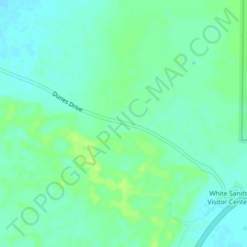
Nom : Carte topographique Chihuahuan Desert, altitude, relief.
Lieu : Chihuahuan Desert, Otero County, New Mexico, United States (32.78739 -106.18660 32.78749 -106.18650)
Altitude moyenne : 1’221 m
Altitude minimum : 1’215 m
Altitude maximum : 1’228 m
There are several larger mountain ranges in the Chihuahan Desert, including the Sierra Madre, the Sierra del Carmen, the Organ Mountains, the Franklin Mountains, the Sacramento Mountains, the Chisos Mountains, the Guadalupe Mountains, and the Davis Mountains. These create "sky islands" of cooler, wetter, climates adjacent to, or within the desert, and such elevated areas have both coniferous and broadleaf woodlands, including forests along drainages and favored exposures. The lower elevations of the Sandia–Manzano Mountains, the Magdalena–San Mateo Mountains, and the Gila Region partly border the Chihuahuan Desert and partly border other ecoregions that are not deserts.
Autres cartes topographiques
Cliquez sur une carte pour visualiser sa topographie, son altitude et son relief.
Mayhill
United States > New Mexico > Otero County
Mayhill, Otero County, New Mexico, United States
Altitude moyenne : 2’104 m
Cloudcroft
United States > New Mexico > Otero County
Cloudcroft, Otero County, New Mexico, United States
Altitude moyenne : 2’643 m
Bent
United States > New Mexico > Otero County
Bent, Otero County, New Mexico, 88314, United States
Altitude moyenne : 1’857 m
Cloudcroft
United States > New Mexico > Otero County > Cloudcroft
Cloudcroft, Otero County, New Mexico, 88317, United States
Altitude moyenne : 2’636 m
Sunspot
United States > New Mexico > Otero County
Sunspot, Otero County, New Mexico, 88349, United States
Altitude moyenne : 2’626 m
Tularosa
United States > New Mexico > Otero County > Tularosa
Tularosa, Otero County, New Mexico, 88352, United States
Altitude moyenne : 1’371 m