
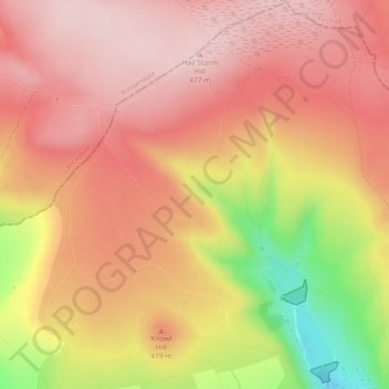
Carte topographique Naden Brook
Carte interactive
Cliquez sur la carte pour afficher l’altitude.
À propos de cette carte
Nom : Carte topographique Naden Brook, altitude, relief.
Altitude moyenne : 392 m
Altitude minimum : 219 m
Altitude maximum : 477 m
Autres cartes topographiques
Cliquez sur une carte pour visualiser sa topographie, son altitude et son relief.
Knowl Hill
United Kingdom > England > Rochdale
Knowl Hill, Rochdale, Greater Manchester, England, OL12 7TX, United Kingdom
Altitude moyenne : 333 m
Norden
United Kingdom > England > Rochdale
Norden, Rochdale, Greater Manchester, England, OL11 5SU, United Kingdom
Altitude moyenne : 203 m
River Irk
United Kingdom > England > Rochdale
River Irk, Rochdale, Greater Manchester, England, United Kingdom
Altitude moyenne : 96 m
Wardle
United Kingdom > England > Rochdale > Wardle
Wardle, Rochdale, Greater Manchester, North West England, England, OL12 9LA, United Kingdom
Altitude moyenne : 225 m
Newhey
United Kingdom > England > Rochdale
Newhey, Rochdale, Greater Manchester, England, OL16 3RZ, United Kingdom
Altitude moyenne : 202 m
Heap Bridge
United Kingdom > England > Rochdale
Heap Bridge, Rochdale, Greater Manchester, England, BL9 7JN, United Kingdom
Altitude moyenne : 114 m
River Spodden
United Kingdom > England > Rochdale
River Spodden, Rochdale, Greater Manchester, North West England, England, OL12 7EJ, United Kingdom
Altitude moyenne : 170 m