
Carte topographique Bellingham
Carte interactive
Cliquez sur la carte pour afficher l’altitude.
À propos de cette carte
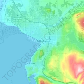
Nom : Carte topographique Bellingham, altitude, relief.
Lieu : Bellingham, Whatcom County, Washington, United States (48.68801 -122.53146 48.81741 -122.39871)
Altitude moyenne : 89 m
Altitude minimum : -6 m
Altitude maximum : 540 m
According to the United States Census Bureau, the city has a total area of 28.90 square miles (74.85 km2), of which, 27.08 square miles (70.14 km2) is land and 1.82 square miles (4.71 km2) is water. The lowest elevations are at sea level along the waterfront. Alabama Hill is one of the higher points in the city at about 500 feet (150 m). Elevations of 800 feet (240 m) are found near Yew Street Hill north of Lake Padden and near Galbraith Mountain. South and eastward of the city limits are taller foothills of the North Cascades mountains. Mount Baker is the largest peak in the local area, with a summit elevation of 10,778 feet (3,285 m) that is only 31 miles (50 km) from Bellingham Bay. Mount Baker is visible from many parts of the city and western Whatcom County. Lake Whatcom forms part of the eastern boundary of the city, while many smaller lakes and wetland areas are found around the region.
Autres cartes topographiques
Cliquez sur une carte pour visualiser sa topographie, son altitude et son relief.
Lummi Island
United States > Washington > Whatcom County
Lummi Island, Whatcom County, Washington, United States
Altitude moyenne : 24 m
Ross Lake
United States > Washington > Whatcom County
Ross Lake, Whatcom County, Washington, United States
Altitude moyenne : 1’314 m
Hampton
United States > Washington > Whatcom County
Hampton, Whatcom County, Washington, 98276, United States
Altitude moyenne : 24 m
Diablo Lake
United States > Washington > Whatcom County
Diablo Lake, Whatcom County, Washington, United States
Altitude moyenne : 643 m
Custer
United States > Washington > Whatcom County
Custer, Whatcom County, Washington, 98240, United States
Altitude moyenne : 20 m
Balford
United States > Washington > Whatcom County
Balford, Whatcom County, Washington, 98266, United States
Altitude moyenne : 342 m
Acme
United States > Washington > Whatcom County
Acme, Whatcom County, Washington, 98220, United States
Altitude moyenne : 420 m
Birch Bay
United States > Washington > Whatcom County
Birch Bay, Whatcom County, Washington, United States
Altitude moyenne : 21 m
Point Roberts
United States > Washington > Whatcom County > Point Roberts
Point Roberts, Whatcom County, Washington, 98281, United States
Altitude moyenne : 9 m
Ferndale
United States > Washington > Whatcom County > Ferndale
Ferndale, Whatcom County, Washington, 98248, United States
Altitude moyenne : 29 m
Sudden Valley
United States > Washington > Whatcom County
Sudden Valley, Whatcom County, Washington, 98228, United States
Altitude moyenne : 239 m
Ferndale
United States > Washington > Whatcom County
Ferndale, Whatcom County, Washington, United States
Altitude moyenne : 29 m
Bellingham
United States > Washington > Whatcom County > Bellingham
Bellingham, Whatcom County, Washington, 98225-3243, United States
Altitude moyenne : 129 m
Blaine
United States > Washington > Whatcom County > Blaine
Blaine, Whatcom County, Washington, United States
Altitude moyenne : 23 m