
Carte topographique Nubra
Carte interactive
Cliquez sur la carte pour afficher l’altitude.
À propos de cette carte
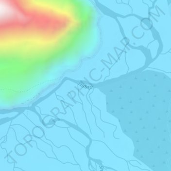
Nom : Carte topographique Nubra, altitude, relief.
Lieu : Nubra, Leh, Leh District, Jammu and Kashmir, India (34.59068 77.57797 34.59798 77.60057)
Altitude moyenne : 3’205 m
Altitude minimum : 3’097 m
Altitude maximum : 3’982 m
Autres cartes topographiques
Cliquez sur une carte pour visualiser sa topographie, son altitude et son relief.
Ladakh Range
India > Jammu and Kashmir > Leh
Ladakh Range, Leh, Leh District, Jammu and Kashmir, India
Altitude moyenne : 4’936 m
Zanskar
India > Jammu and Kashmir > Leh
Zanskar, Leh, Leh District, Jammu and Kashmir, India
Altitude moyenne : 3’933 m
Stok Kangri
India > Jammu and Kashmir > Leh
Stok Kangri, Leh, Leh District, Jammu and Kashmir, India
Altitude moyenne : 5’563 m