
Carte topographique Udaipur
Carte interactive
Cliquez sur la carte pour afficher l’altitude.
À propos de cette carte
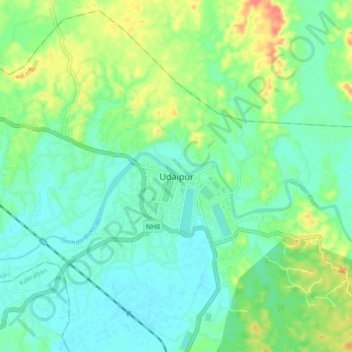
Nom : Carte topographique Udaipur, altitude, relief.
Lieu : Udaipur, Matarbari, Gomati, Tripura, 799120, India (23.50162 91.45176 23.58162 91.53176)
Altitude moyenne : 33 m
Altitude minimum : 16 m
Altitude maximum : 70 m
Udaipur is located at 23°32′N 91°29′E / 23.53°N 91.48°E / 23.53; 91.48. It has an average elevation of 22 metres (72 feet).The Gomati river passes through the heart of Udaipur and helps in irrigation of its lands.