
Carte topographique Bliss
Carte interactive
Cliquez sur la carte pour afficher l’altitude.
À propos de cette carte
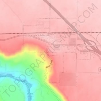
Nom : Carte topographique Bliss, altitude, relief.
Lieu : Bliss, Gooding County, Idaho, United States (42.91362 -114.95932 42.93088 -114.93457)
Altitude moyenne : 962 m
Altitude minimum : 811 m
Altitude maximum : 1’007 m
Autres cartes topographiques
Cliquez sur une carte pour visualiser sa topographie, son altitude et son relief.
Hagerman
United States > Idaho > Gooding County
Hagerman, Gooding County, Idaho, 83332, United States
Altitude moyenne : 900 m
Malad Gorge State Park
United States > Idaho > Gooding County
Malad Gorge State Park, Gooding County, Idaho, 83332, United States
Altitude moyenne : 958 m
Ritter Island
United States > Idaho > Gooding County
Ritter Island, Gooding County, Idaho, United States
Altitude moyenne : 943 m
Wendell
United States > Idaho > Gooding County > Wendell
Wendell, Gooding County, Idaho, 83355, United States
Altitude moyenne : 1’044 m