Géolocaliser

Carte topographique Yumthang

Cliquez sur la carte pour afficher l’altitude.

À propos de cette carte

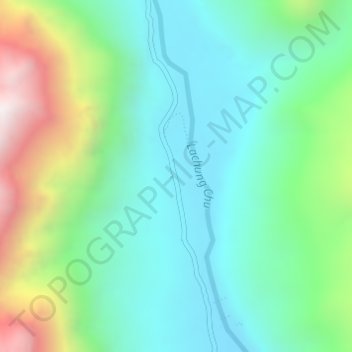
Nom : Carte topographique Yumthang, altitude, relief.

Lieu : Yumthang, Chungthang, Mangan, Sikkim, India (27.79426 88.69332 27.81426 88.71332)

Altitude moyenne : 3’935 m

Altitude minimum : 3’589 m

Altitude maximum : 4’816 m

Autres cartes topographiques

Cliquez sur une carte pour visualiser sa topographie, son altitude et son relief.

South Lhonak Glacier

India > Sikkim > Chungthang

Altitude moyenne : 5’830 m

Gurudongmar

India > Sikkim > Chungthang

Gurudongmar Lake is one of the highest lakes in the world and in India, at an elevation of 5,430 m (17,800 ft) according to the Government of Sikkim. It is located in the Great Himalayas in the Mangan District in Indian state of Sikkim, and considered sacred by Buddhists and Sikhs. The lake is named after…

Altitude moyenne : 5’232 m

Lachung Chu

India > Sikkim > Chungthang > Lachung

Altitude moyenne : 4’332 m

Zemu Chu

India > Sikkim > Chungthang

Altitude moyenne : 3’657 m

Zemu Glacier

India > Sikkim > Chungthang

Altitude moyenne : 5’510 m

Équipez-vous pour votre prochaine aventure :

🧴Crèmes solaires haute protection - Protection UV renforcée
📚Guides de trekking - Préparer ses expéditions
🧦Chaussettes de randonnée - Chaussettes techniques anti-ampoules
📏Podomètre de distance - Mesurez précisément vos pas et la distance parcourue lors de vos sorties
🧥Lessive pour vêtements techniques - Préservez l'imperméabilité de vos vestes haut de gamme

En tant que Partenaire Amazon, ce site perçoit une commission sur les achats éligibles sans surcoût pour vous.