
Carte topographique Muntinlupa
Carte interactive
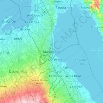
Cliquez sur la carte pour afficher l’altitude.
À propos de cette carte
Nom : Carte topographique Muntinlupa, altitude, relief.
Altitude moyenne : 41 m
Altitude minimum : -3 m
Altitude maximum : 314 m
There are three plausible origins of the name of the city: First, is its association with the thin topsoil in the area; second, residents, purportedly replying to a question by Spaniards in the 16th century what the name of their place was, said “Monte sa Lupa”—apparently mistaking the question for what card game they were playing; third, the topographical nature of the area, where the term Monte or mountain was expanded to Muntinlupa or mountain land. Based on the 1987 Philippine constitution, it is spelled as Muntinglupa, instead of Muntinlupa.
Autres cartes topographiques
Cliquez sur une carte pour visualiser sa topographie, son altitude et son relief.
Sucat
Sucat, Muntinlupa, Southern Manila District, Metro Manila, Philippines
Altitude moyenne : 11 m
Alabang
Alabang, Muntinlupa, Southern Manila District, Metro Manila, 1781, Philippines
Altitude moyenne : 13 m
Cupang
Cupang, Muntinlupa, Southern Manila District, Metro Manila, Philippines
Altitude moyenne : 8 m
Bayanan
Bayanan, Muntinlupa, Southern Manila District, Metro Manila, Philippines
Altitude moyenne : 8 m
Poblacion
Poblacion, Muntinlupa, Southern Manila District, Metro Manila, 1776, Philippines
Altitude moyenne : 21 m
Ayala Alabang
Ayala Alabang, Muntinlupa, Southern Manila District, Metro Manila, Philippines
Altitude moyenne : 33 m
Tunasan
Tunasan, Muntinlupa, Southern Manila District, Metro Manila, Philippines
Altitude moyenne : 19 m
Putatan
Putatan, Muntinlupa, Southern Manila District, Metro Manila, 1772, Philippines
Altitude moyenne : 16 m
La Guerta
La Guerta, Muntinlupa, Southern Manila District, Metro Manila, 1770, Philippines
Altitude moyenne : 16 m
Cupang
Philippines > Muntinlupa > Cupang
Cupang, Muntinlupa, NCR, Fourth District, Metro Manila, 1771, Philippines
Altitude moyenne : 19 m