
Carte topographique Wymondham
Cliquez sur la carte pour afficher l’altitude.
Wymondham
Wymondham's topography is marked by its river meadow and flat, low-lying agricultural landscape, much like the rest of East Anglia. The parish has an area of 17.11 square miles (44.31 km2). The geology is based on chalk, with a layer of boulder clay laid down in the last ice age. The River Tiffey, flowing north, forms a boundary between the built-up town centre and the rural southern part of the parish.
À propos de cette carte
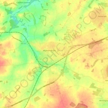
Nom : Carte topographique Wymondham, altitude, relief.
Lieu : Wymondham, South Norfolk, Norfolk, England, NR18, United Kingdom (52.53735 1.07661 52.61070 1.16459)
Altitude moyenne : 43 m
Altitude minimum : 14 m
Altitude maximum : 65 m
Autres cartes topographiques
Cliquez sur une carte pour visualiser sa topographie, son altitude et son relief.
Poringland Wood
United Kingdom > England > Norfolk > South Norfolk > Framingham Earl
Altitude moyenne : 50 m
Fundenhall
United Kingdom > England > Norfolk > South Norfolk > Ashwellthorpe and Fundenhall
Altitude moyenne : 50 m
Highoak
United Kingdom > England > Norfolk > South Norfolk > Morley St Botolph
Altitude moyenne : 47 m
Beckhithe
United Kingdom > England > Norfolk > South Norfolk > Little Melton > Beckhithe
Altitude moyenne : 37 m
Forncett Saint Mary
United Kingdom > England > Norfolk > South Norfolk > Forncett St Peter
Altitude moyenne : 43 m