
Carte topographique Thun
Carte interactive
Cliquez sur la carte pour afficher l’altitude.
À propos de cette carte
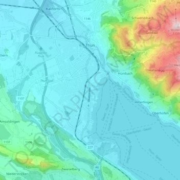
Nom : Carte topographique Thun, altitude, relief.
Altitude moyenne : 637 m
Altitude minimum : 545 m
Altitude maximum : 1’138 m
The center of Thun is located on the Aare, just downstream of the point where that river flows out of Lake Thun, and encompasses both banks of the river and an island between. The town covers an area of 21.6 km2 (8.3 sq mi), with the town boundaries reaching up to 4 km (2.5 mi) from the town centre. The town ranges in altitude between about 560 m (1,840 ft), in the town center, and 1,170 m (3,840 ft), on its eastern boundary.
Autres cartes topographiques
Cliquez sur une carte pour visualiser sa topographie, son altitude et son relief.
Merligen
Switzerland > Bern > Thun administrative district
Merligen, Sigriswil, Horrenbach-Buchen, Thun administrative district, Oberland administrative region, Bern, 3658, Switzerland
Altitude moyenne : 767 m
Hünibach
Switzerland > Bern > Thun administrative district
Hünibach, Hilterfingen, Horrenbach-Buchen, Thun administrative district, Oberland administrative region, Bern, 3626, Switzerland
Altitude moyenne : 689 m
Oberstocken
Switzerland > Bern > Thun administrative district > Stocken-Höfen
Oberstocken, Stocken-Höfen, Thun administrative district, Oberland administrative region, Bern, 3632, Switzerland
Altitude moyenne : 1’100 m