
Carte topographique Bonners Ferry
Carte interactive
Cliquez sur la carte pour afficher l’altitude.
À propos de cette carte
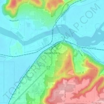
Nom : Carte topographique Bonners Ferry, altitude, relief.
Altitude moyenne : 584 m
Altitude minimum : 531 m
Altitude maximum : 716 m
Bonners Ferry is located 27 miles (43.5 km) south of the Canada-United States border at 48°41′32″N 116°19′3″W / 48.69222°N 116.31750°W / 48.69222; -116.31750 (48.692110, −116.317626), at an altitude of 1,896 feet (578 m). According to the United States Census Bureau, the city has a total area of 2.61 square miles (6.76 km2), of which 2.44 square miles (6.32 km2) is land and 0.17 square miles (0.44 km2) is water.