
Carte topographique Sanggau
Carte interactive
Cliquez sur la carte pour afficher l’altitude.
À propos de cette carte
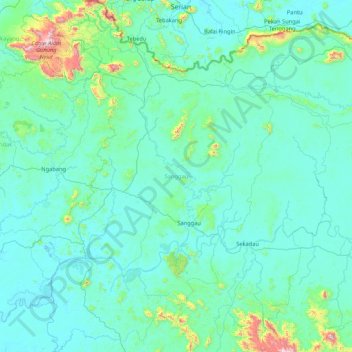
Nom : Carte topographique Sanggau, altitude, relief.
Lieu : Sanggau, Kalimantan occidental, Kalimantan, Indonésie (-0.49952 109.84214 1.19993 111.01312)
Altitude moyenne : 106 m
Altitude minimum : -1 m
Altitude maximum : 1’563 m
Autres cartes topographiques
Cliquez sur une carte pour visualiser sa topographie, son altitude et son relief.
Bangka Belitung Laut
Indonésie > Kalimantan occidental > Pontianak
Bangka Belitung Laut, Pontianak Tenggara, Pontianak, Kalimantan occidental, 78242, Indonésie
Altitude moyenne : 3 m
Jayawijaya
Indonésie > Kalimantan occidental
Jayawijaya, Kalimantan occidental, Indonésie
Altitude moyenne : 5 m
Sanggau
Indonésie > Kalimantan occidental > Sanggau
Sanggau, Kalimantan occidental, Indonésie
Altitude moyenne : 42 m