
Faire un don
Équipez-vous pour votre prochaine aventure :
En tant que Partenaire Amazon, ce site perçoit une commission sur les achats éligibles sans surcoût pour vous.
Carte topographique Newton
Cliquez sur la carte pour afficher l’altitude.
Faire un don
Équipez-vous pour votre prochaine aventure :
En tant que Partenaire Amazon, ce site perçoit une commission sur les achats éligibles sans surcoût pour vous.
Newton
Newton has grown around a formation of seven hills. "The general features of Newton are not without interest. Seven principal elevations mark its surface, like the seven hills of ancient Rome, with the difference that the seven hills of Newton are much more distinct than the seven hills of Rome: Nonantum Hill, Waban Hill, Chestnut Hill, Bald Pate, Oak Hill, Institution Hill and Mount Ida."
Faire un don
Équipez-vous pour votre prochaine aventure :
En tant que Partenaire Amazon, ce site perçoit une commission sur les achats éligibles sans surcoût pour vous.
À propos de cette carte
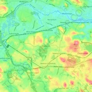
Nom : Carte topographique Newton, altitude, relief.
Altitude moyenne : 43 m
Altitude minimum : -3 m
Altitude maximum : 186 m
Faire un don
Équipez-vous pour votre prochaine aventure :
En tant que Partenaire Amazon, ce site perçoit une commission sur les achats éligibles sans surcoût pour vous.
Autres cartes topographiques
Cliquez sur une carte pour visualiser sa topographie, son altitude et son relief.