
Carte topographique Union Mills
Carte interactive
Cliquez sur la carte pour afficher l’altitude.
À propos de cette carte
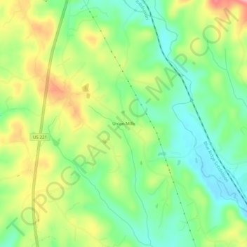
Nom : Carte topographique Union Mills, altitude, relief.
Altitude moyenne : 326 m
Altitude minimum : 274 m
Altitude maximum : 402 m
Autres cartes topographiques
Cliquez sur une carte pour visualiser sa topographie, son altitude et son relief.
Rutherfordton
United States > North Carolina > Rutherford County
Rutherfordton, Rutherford County, North Carolina, United States
Altitude moyenne : 302 m
Rutherfordton
United States > North Carolina > Rutherford County > Rutherfordton
Rutherfordton, Rutherford County, North Carolina, 28139, United States
Altitude moyenne : 300 m
Lake Lure
United States > North Carolina > Rutherford County
Lake Lure, Rutherford County, North Carolina, 28746, United States
Altitude moyenne : 363 m
Spindale
United States > North Carolina > Rutherford County > Spindale
Spindale, Rutherford County, North Carolina, 28160, United States
Altitude moyenne : 299 m
Chimney Rock
United States > North Carolina > Rutherford County > Chimney Rock
Chimney Rock, Rutherford County, North Carolina, 28720, United States
Altitude moyenne : 550 m