
Carte topographique Montalvo
Carte interactive
Cliquez sur la carte pour afficher l’altitude.
À propos de cette carte
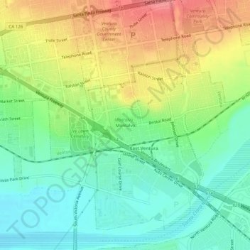
Nom : Carte topographique Montalvo, altitude, relief.
Altitude moyenne : 42 m
Altitude minimum : 8 m
Altitude maximum : 92 m
Autres cartes topographiques
Cliquez sur une carte pour visualiser sa topographie, son altitude et son relief.
Junipero Serra Park
United States > California > Ventura County > Ventura
Junipero Serra Park, Ventura, Ventura County, CAL Fire Southern Region, California, United States
Altitude moyenne : 49 m
Casitas Springs
United States > California > Ventura County > Ventura > Casitas Springs
Casitas Springs, Ventura, Ventura County, California, 93022, United States
Altitude moyenne : 182 m