
Carte topographique Whitefish Dunes State Park
Carte interactive
Cliquez sur la carte pour afficher l’altitude.
À propos de cette carte
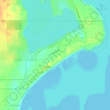
Nom : Carte topographique Whitefish Dunes State Park, altitude, relief.
Altitude moyenne : 181 m
Altitude minimum : 172 m
Altitude maximum : 207 m
Autres cartes topographiques
Cliquez sur une carte pour visualiser sa topographie, son altitude et son relief.
Potawatomi State Park
United States > Wisconsin > Door County > Sturgeon Bay
Potawatomi State Park, North Duluth Avenue, Sturgeon Bay, Town of Nasewaupee, Door County, Wisconsin, 54235, United States
Altitude moyenne : 195 m