
Carte topographique Roxborough
Cliquez sur la carte pour afficher l’altitude.
Roxborough
Since the 1950s, most of Philadelphia's major television and FM radio stations have located their transmission towers in Roxborough because of its hilly terrain and high elevation. The tallest of these towers, the American Tower, stands approximately 1,250 feet (381m) tall. Public television station "MiND", once called "WYBE", was also formerly located in Upper Roxborough, close to neighboring Andorra.
À propos de cette carte
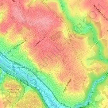
Nom : Carte topographique Roxborough, altitude, relief.
Altitude moyenne : 63 m
Altitude minimum : 5 m
Altitude maximum : 98 m
Autres cartes topographiques
Cliquez sur une carte pour visualiser sa topographie, son altitude et son relief.
Pastorius Park
United States > Pennsylvania > Philadelphia County > Philadelphia
Altitude moyenne : 108 m
Strawberry Mansion
United States > Pennsylvania > Philadelphia County > Philadelphia
Altitude moyenne : 31 m
East Passyunk Community Recreation Center
United States > Pennsylvania > Philadelphia County > Philadelphia
Altitude moyenne : 9 m
Bartram's Garden
United States > Pennsylvania > Philadelphia County > Philadelphia
Altitude moyenne : 13 m