Géolocaliser

Carte topographique Kottur

Cliquez sur la carte pour afficher l’altitude.

À propos de cette carte

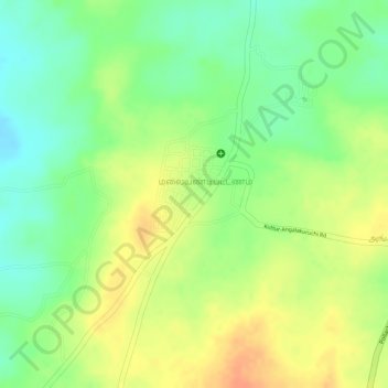
Nom : Carte topographique Kottur, altitude, relief.

Lieu : Kottur, Pollachi, Coimbatore District, Tamil Nadu, India (10.52596 76.97370 10.54753 76.98584)

Altitude moyenne : 296 m

Altitude minimum : 273 m

Altitude maximum : 317 m

Autres cartes topographiques

Cliquez sur une carte pour visualiser sa topographie, son altitude et son relief.

Singanallur

India > Tamil Nadu > Pollachi

Altitude moyenne : 248 m

Pollachi

India > Tamil Nadu > Pollachi

Pollachi is located at 10°39′43″N 77°00′23″E / 10.662°N 77.0065°E / 10.662; 77.0065. It has an average elevation of 293 metres (961 ft). Aliyar river passes about 10 kilometres (6.2 mi) away from the town and the town receives rainfall from Southwest monsoon due to the presence of Palghat gap.

Altitude moyenne : 289 m

Thensangampalayam

India > Tamil Nadu > Pollachi

Altitude moyenne : 272 m

Puravipalayam

India > Tamil Nadu > Pollachi

Altitude moyenne : 236 m

Kattampatti

India > Tamil Nadu > Pollachi

Altitude moyenne : 393 m

Arasampalayam

India > Tamil Nadu > Pollachi

Altitude moyenne : 358 m

Kottur-Malayandipattinam

India > Tamil Nadu > Pollachi

Altitude moyenne : 293 m

Ambarampalayam

India > Tamil Nadu > Pollachi

Altitude moyenne : 238 m

Anaimalai

India > Tamil Nadu > Pollachi

Altitude moyenne : 262 m

Sethumadai

India > Tamil Nadu > Pollachi

Altitude moyenne : 338 m

Pollachi

India > Tamil Nadu > Pollachi

Pollachi is located at 10°39′43″N 77°00′23″E / 10.662°N 77.0065°E / 10.662; 77.0065 near the center of the South Indian Peninsula, surrounded by Western Ghats. It has an average elevation of 293 metres (961 ft) on the banks of Aliyar river. The area is hilly and rocky, drained by several…

Altitude moyenne : 289 m

Équipez-vous pour votre prochaine aventure :

💧Poche à eau pour sac - Hydratez-vous facilement sans vous arrêter de marcher
📢Sifflet de secours - Pour signaler votre position en cas de brouillard ou d'accident
🧥Vestes imperméables de randonnée - Protection contre la pluie et le vent en terrain variable
📍GPS de randonnée - Navigation précise hors réseau
🦵Guêtres de marche - Empêchent la neige, la boue et les cailloux d'entrer dans vos chaussures

En tant que Partenaire Amazon, ce site perçoit une commission sur les achats éligibles sans surcoût pour vous.