
Carte topographique Montague Township
Carte interactive
Cliquez sur la carte pour afficher l’altitude.
À propos de cette carte
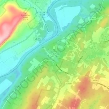
Nom : Carte topographique Montague Township, altitude, relief.
Lieu : Montague Township, Sussex County, New Jersey, United States (41.28315 -74.81350 41.32315 -74.77350)
Altitude moyenne : 178 m
Altitude minimum : 104 m
Altitude maximum : 301 m
Montague Township is a township in Sussex County, in the U.S. state of New Jersey, in the New York City Metropolitan Area. As of the 2020 United States census, the township's population was 3,792, a decrease of 55 (−1.4%) from the 2010 census count of 3,847, which in turn reflected an increase of 435 (+12.7%) from the 3,412 counted in the 2000 census. High Point, within Montague Township, is the highest elevation within New Jersey at an altitude of 1,803 feet (550 m) above sea level. Montague is also the northernmost municipality in the state of New Jersey.
Autres cartes topographiques
Cliquez sur une carte pour visualiser sa topographie, son altitude et son relief.
High Point State Park
United States > New Jersey > Sussex County > Montague Township
High Point State Park, Montague Township, Sussex County, New Jersey, 07827, United States
Altitude moyenne : 255 m