
Carte topographique Frisco
Carte interactive
Cliquez sur la carte pour afficher l’altitude.
À propos de cette carte
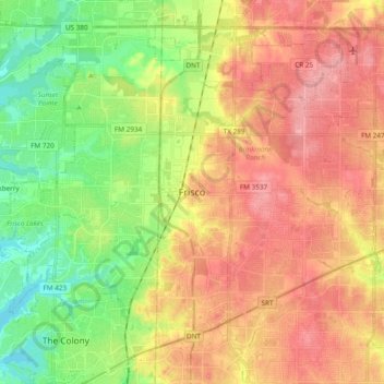
Nom : Carte topographique Frisco, altitude, relief.
Lieu : Frisco, Collin County, Texas, United States (33.08150 -96.92279 33.21958 -96.73257)
Altitude moyenne : 201 m
Altitude minimum : 152 m
Altitude maximum : 247 m
In 1902, a line of the St. Louis–San Francisco Railway ("the Frisco") was being built through the area, and periodic watering stops were needed along the route for the steam locomotives. The current settlement of Lebanon was on the Preston Ridge, and was too high in elevation, so the watering stop was placed about 4 miles (6 km) to the west on lower ground. A community grew around this train stop, and some Lebanon residents moved their houses to the new community on logs. The new town was originally named Emerson, but the U.S. Postal Service rejected the name as too similar to another community, Emberson, in Lamar County.
Autres cartes topographiques
Cliquez sur une carte pour visualiser sa topographie, son altitude et son relief.
Prosper
United States > Texas > Collin County
Prosper, Collin County, Texas, 75078, United States
Altitude moyenne : 209 m
Murphy
United States > Texas > Collin County
Murphy, Collin County, Texas, 75094, United States
Altitude moyenne : 169 m
Melissa
United States > Texas > Collin County
Melissa, Collin County, Texas, 75454, United States
Altitude moyenne : 195 m
Nevada
United States > Texas > Collin County
Nevada, Collin County, Texas, United States
Altitude moyenne : 179 m
Fairview
United States > Texas > Collin County
Fairview, Collin County, Texas, United States
Altitude moyenne : 192 m
Blue Ridge
United States > Texas > Collin County
Blue Ridge, Collin County, Texas, United States
Altitude moyenne : 174 m
Plano
United States > Texas > Collin County
Plano, Collin County, Texas, United States
Altitude moyenne : 196 m
Frisco
United States > Texas > Collin County > Frisco
Frisco, Collin County, Texas, 75034, United States
Altitude moyenne : 191 m
Desert
United States > Texas > Collin County
Desert, Collin County, Texas, United States
Altitude moyenne : 206 m
Plano
United States > Texas > Collin County > Plano
Plano, Collin County, Texas, 75074, United States
Altitude moyenne : 181 m
Parker
United States > Texas > Collin County > Parker
Parker, Collin County, Texas, United States
Altitude moyenne : 180 m
Allen
United States > Texas > Collin County
Allen, Collin County, Texas, United States
Altitude moyenne : 200 m
Wylie
United States > Texas > Collin County
Wylie, Collin County, Texas, United States
Altitude moyenne : 160 m
Beverly Hill
United States > Texas > Collin County > Beverly Hill
Beverly Hill, Collin County, Texas, United States
Altitude moyenne : 154 m
Lavon Beach Estates
United States > Texas > Collin County > Lavon Beach Estates
Lavon Beach Estates, Collin County, Texas, 75121, United States
Altitude moyenne : 154 m
Farmersville
United States > Texas > Collin County
Farmersville, Collin County, Texas, 75442, United States
Altitude moyenne : 187 m
McKinney
United States > Texas > Collin County
McKinney, Collin County, Texas, United States
Altitude moyenne : 193 m