
Carte topographique Horseshoe Bend
Carte interactive
Cliquez sur la carte pour afficher l’altitude.
À propos de cette carte
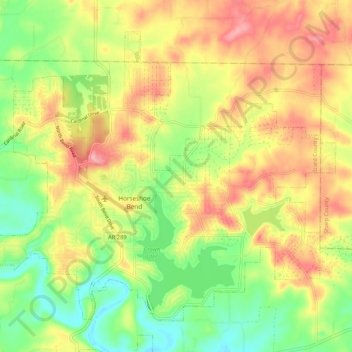
Nom : Carte topographique Horseshoe Bend, altitude, relief.
Lieu : Horseshoe Bend, Izard County, Arkansas, 72512, United States (36.19148 -91.79236 36.26120 -91.68736)
Altitude moyenne : 220 m
Altitude minimum : 160 m
Altitude maximum : 284 m
The Horseshoe Bend Airport, FAA identifier is 6M2, is owned and operated by the city. The runway is 4,524 ft. x 60 ft. and is paved. It is located at 36°13′3″N 91°45′3″W / 36.21750°N 91.75083°W / 36.21750; -91.75083 (36.2213694, -91.7554833) at an elevation of 782 ft. / 238 m. Its variation is 03E.