
Carte topographique Horsham Township
Carte interactive
Cliquez sur la carte pour afficher l’altitude.
À propos de cette carte
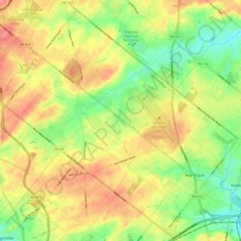
Nom : Carte topographique Horsham Township, altitude, relief.
Altitude moyenne : 93 m
Altitude minimum : 56 m
Altitude maximum : 128 m
The township's early social and economic life revolved around this Meeting House. In a similar way, Prospectville, originally known as Cashtown, was established at the junction of two roads, Limekiln Pike and Horsham Road. This portion of Limekiln Pike was an extension of the original segment established in 1693 to provide a thoroughfare between Old York Road and the limekilns of Thomas Fitzwater in Upper Dublin Township. Prospectville, on a high elevation point within the township, offering a resting spot with a tavern for those traveling along either Limekiln Pike or Horsham Road. Here lived several generations of the Simpson family, one of whom was the mother of Ulysses S. Grant, the 18th president of the United States.
Autres cartes topographiques
Cliquez sur une carte pour visualiser sa topographie, son altitude et son relief.
Horsham
United States > Pennsylvania > Montgomery County > Horsham Township
Horsham, Horsham Township, Montgomery County, Pennsylvania, 19044, United States
Altitude moyenne : 89 m
Fairoaks
United States > Pennsylvania > Montgomery County > Horsham Township > Horsham
Fairoaks, Horsham, Horsham Township, Montgomery County, Pennsylvania, 19040, United States
Altitude moyenne : 84 m
Wynmere Downs
United States > Pennsylvania > Montgomery County > Horsham Township
Wynmere Downs, Horsham Township, Montgomery County, Pennsylvania, 19044, United States
Altitude moyenne : 98 m
Prospectville
United States > Pennsylvania > Montgomery County > Horsham Township
Prospectville, Horsham Township, Montgomery County, Pennsylvania, 19044, United States
Altitude moyenne : 95 m
Horsham
United States > Pennsylvania > Montgomery County > Horsham Township > Horsham
Horsham, Horsham Township, Montgomery County, Pennsylvania, 19044, United States
Altitude moyenne : 91 m