Géolocaliser

Carte topographique Felinfoel

Cliquez sur la carte pour afficher l’altitude.

À propos de cette carte

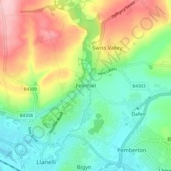
Nom : Carte topographique Felinfoel, altitude, relief.

Lieu : Felinfoel, Carmarthenshire, Wales, SA15 4LT, United Kingdom (51.67762 -4.16702 51.71762 -4.12702)

Altitude moyenne : 66 m

Altitude minimum : 0 m

Altitude maximum : 178 m

Autres cartes topographiques

Cliquez sur une carte pour visualiser sa topographie, son altitude et son relief.

Whitland

United Kingdom > Wales > Carmarthenshire > Whitland

Altitude moyenne : 43 m

Cynwyl Gaeo

United Kingdom > Wales > Carmarthenshire

Altitude moyenne : 254 m

Bryn Iwan

United Kingdom > Wales > Carmarthenshire

Altitude moyenne : 252 m

Whitland

United Kingdom > Wales > Carmarthenshire

Altitude moyenne : 52 m

River Towy

United Kingdom > Wales > Carmarthenshire

Altitude moyenne : 215 m

Llanedi

United Kingdom > Wales > Carmarthenshire > Llanedi

Altitude moyenne : 104 m

Newcastle Emlyn

United Kingdom > Wales > Carmarthenshire

Altitude moyenne : 82 m

Cilycwm

United Kingdom > Wales > Carmarthenshire

Altitude moyenne : 256 m

Coed Tregib

United Kingdom > Wales > Carmarthenshire > Llandeilo

Altitude moyenne : 82 m

Llyn y Fan Fach

United Kingdom > Wales > Carmarthenshire

Llyn y Fan Fach (Welsh meaning "little lake of the peak") is a lake of approximately 10 hectares (25 acres) on the northern margin of the Black Mountain in Carmarthenshire, South Wales and lying within the Brecon Beacons National Park. The lake lies at an altitude of approximately 1,660 feet (510 m),…

Altitude moyenne : 549 m

River Teifi

United Kingdom > Wales > Carmarthenshire

Altitude moyenne : 155 m

Llanwinio

United Kingdom > Wales > Carmarthenshire

Altitude moyenne : 164 m

Llannon

United Kingdom > Wales > Carmarthenshire > Llannon

Altitude moyenne : 144 m

Meidrim

United Kingdom > Wales > Carmarthenshire

Altitude moyenne : 91 m

Llanycrwys

United Kingdom > Wales > Carmarthenshire

Altitude moyenne : 248 m

Rhos

United Kingdom > Wales > Carmarthenshire > Rhos

Altitude moyenne : 206 m

Llyn Taliaris

United Kingdom > Wales > Carmarthenshire

Altitude moyenne : 167 m

Whitland

United Kingdom > Wales > Carmarthenshire

Altitude moyenne : 42 m

Trelech

United Kingdom > Wales > Carmarthenshire

Altitude moyenne : 182 m

Llanedi

United Kingdom > Wales > Carmarthenshire > Llanedi

Altitude moyenne : 104 m

Abernant

United Kingdom > Wales > Carmarthenshire

Altitude moyenne : 158 m

Équipez-vous pour votre prochaine aventure :

🧥Vestes imperméables de randonnée - Protection contre la pluie et le vent en terrain variable
📢Sifflet de secours - Pour signaler votre position en cas de brouillard ou d'accident
🧼Savon biodégradable - Lavez-vous ou nettoyez votre matériel sans polluer les rivières
🗻Équipement d’alpinisme - Matériel essentiel haute montagne
📟GPS de randonnée - L'outil indispensable pour suivre vos tracés et coordonnées en haute altitude

En tant que Partenaire Amazon, ce site perçoit une commission sur les achats éligibles sans surcoût pour vous.